Project by: Seth Wing and Jackie Tran
Abstract
NASA's Terra moderate resolution imaging spectroradiometer (MODIS) data are used to understand large scale vegetative changes on the African continent. This, in conjunction with the use of Landsat imagery from 1985 to 2010, are used for a more detailed view of particular study areas within Western Botswana. This data can then be examined for photosynthetic production in an arid environment. Using normalized difference vegetation index (NDVI) analysis we have identified areas with particular vegetative growth in four different study locations during the time span mentioned. Doing this gives a clear example of how plant growth changes within the aridity of the Kalahari as well as over a 25 year time span. The results from our analysis shows that from 1985 to 2010 there has been a net increase in vegetative cover along the Kalahari Transect in all four locations studied. A total of 186.5% vegetative growth increase was calculated within NDVI bands 0.5 to 1.0; with Tshane leading this figure at a total increase of 339.8% in vegetation within NDVI bands 0.5 to 1.0. This result is probably correlated to increased precipitation in the region, which has fluctuated over the last 25 years, but has seen episodes of increased precipitation at particular times.
Introduction
Savannah biomes constitute one of the Earth's major terrestrial carbon pools and are responsible for about 13% of global net primary productivity (Woodward). They can either be large carbon sinks or large carbon sources, depending on how they are managed and the time span in consideration. Since Southern African savannas presently have low anthropogenic disturbance, and since the human population is expected to rise dramatically here, they have the potential to experience a significant change in carbon storage and either contribute to, or alleviate, the atmospheric carbon pool significantly.
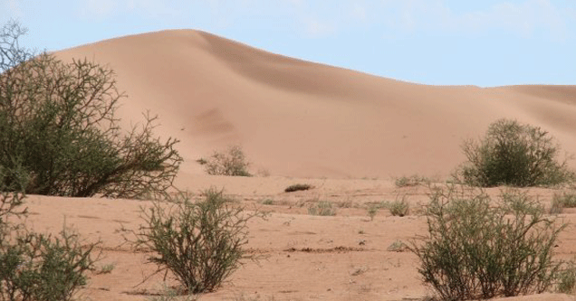
The Kalahari Transect follows a South to North increase in mean annual rainfall from 250 mm/yr to 1000 mm/yr on consistent, sandy soils deposited during the Pleistocene (Woodward). The large gradient in both the mean and variation of annual rainfall results in dramatic changes in vegetation along the Transect. Vegetation type ranges from open shrub land in the south to partially closed woodlands in the north. Thus, the Kalahari Transect is a unique location to study landscape processes and assess the impact of global change in Savannah ecosystems as well study global human impacts on a relatively untouched landscape.
Data and Analysis Methods
The primary data set used for this study is the NDVI. This is an index derived from broadband measurements within both the visible and infrared portions of the electromagnetic spectrum. The satellites used to acquire the information on this bandwidth for analysis were the MODIS sensor aboard the Terra satellite as well as Landsat 5. The index is calculated as:
NDVI = (nir - r)/(nir + r)
Where r is equal to a surface reflectance of 550-700 nm (within the visible range) and nir is equal to a reflectance of 730-1000 nm (within infrared) of the electromagnetic spectrum (Anyamba).
The study sites chosen are located along the aforementioned Kalahari Transect, running South to North roughly along line of longitude 21°E. These sites include (from South to North) Bokspits, Tshane, Ghanzi, and Shakawe, as seen on the Google Maps mashup below. From these sites, Landsat 5 images were used for high resolution NDVI data analysis. Within this analysis three spectral bands were chosen for extraction: 0.25 to 0.5, 0.5 to 0.75, and 0.75 to 1.0. Where 0 is equal to no vegetation and 1 is equal to dense vegetation. Precipitation data was also collected along the Kalahari Transect from -28°S to -10°S from the Global Precipitation Climatology Project to show correlation between rainfall and vegetative growth in the region.
Large Scale Data Analysis
Below, large scale data has been presented in order to give viewers a broader understanding of the African continent and it's plant cover. Through this it should become clear how vegetation changes in response to geographic change and how arid environments are distributed over this large area. The data used for these images come from the MODIS sensor on the Terra Satellite, using NDVI Analysis.

MODIS herbaceous plant cover

MODIS tree cover
Site Locations
Below is the specific site locations used for data analysis along the Kalahari Transect. Within each site two data sets were collected from separate years and the data was then compared with one site to the next, as well as in the context of all the sites being analyzed.
View Botswana Soil Sites in a larger map
Results
Remotely Sensed Data

Bokspits

Area (km2) of NDVI spectral band

1985

2010
Tshane


Area (km2) of NDVI spectral band

1985

2010
Ghanzi


Area (km2) of NDVI spectral band

1985

2010
Shakawe


Area (km2) of NDVI spectral band

1985

1995
The Kalahari Transect
In total the Kalahari Transect has seen a significant net increase in vegetative cover from 1985 to 1995 and 2010 (Shakawe lacking Landsat 5 imagery from 2010). The graph below includes only NDVI bands 0.5 - 1.0 to eliminate potential seasonal grasslands of the region and look at denser growth that has longer life spans than one year.

From south to north, sum area (km2) of NDVI spectral bands 0.5 to 1.0
Ground Truthing
Ground truthing is the process of gathering data physically on location, then comparing it to data that has been collected via remote sensing technique. Below is plant density per meter collected on site within Botswana from a team working with UCLA. A 20x20 meter plot was established for each site, then every plant along with its species name was identified within that plot. From that information, a graph can be created showing density of vegetation from one location to the next. Unfortunately Ghanzi data is unavailable, being replaced with data from Kuke, about 285km East by Northeast from Tshane. The ground truthing data shown here conclusively proves the increase in biomass from South to North along the Kalahari Transect and sheds light on how vegetation changes with climatic variables in relatively natural environments.

Influential Factors
Climate
The image below shows the monthly variation of precipitation from -36°S up to -10°S in the southern region of Africa. Precipitation is a major limiting factor to the vegetation of the Kalahari as well as plants globally. This animated image shows clearly the climatic variances throughout the year of 1985 and illustrates where and how rain falls over the southern portion of this continent. It is clear from this simple animation where one would expect to find lower and higher vegetation densities, South to North respectively.

The graph below illustrates yearly mean precipitation from 1985 to 2008 along a latitudinal transect traveling form -28°S to -10°S along line of longitude 21°E. This is roughly the transect in which the sites for this project were chosen, south to north. It is very clear that the Kalahari Transect is dominated by a strong precipitation gradient. It should be noted that this region is often impacted by El Niño/La Niña ENSO events that are not well represented on this chart.

Below is a graph showing mean annual precipitation from 1985 to 2008 along line of longitude 21°E. It is useful because it shows the annual variation in rainfall yet depicts the clear change in rainfall from South to North. It also shows the slight increase in rainfall over the 23 years this graph covers, likely a contributing factor to the increased vegetation over the same time period along the Kalahari Transect.

Discussion
There have been many studies concentrated on the Kalahari Transect for its untouched landscape and strong precipitation gradient. It has allowed for clear research to be done looking at how ecosystems react to changes in climactic variables with little anthropogenic influences. From soils and plants to fire susceptibility and aerosols, the region is key to understanding how earth system processes function in a quickly changing world.
One study that is similar to this one is Seasonal to Interannual Variability of Vegetation and Fire at SAFARI 2000 Sites Inferred from Advanced Very High Resolution Radiometer Time Series Data by Anyamba et.al. This analyzed AVHRR imagery and detected seasonal variation of vegetation and its response to ENSO events. The SAFARI 2000 - Kalahari Transect Wet Season Campaign of year 2000 by Shugart et.al. is another example of a study similar to this one, looking at climatic changes along the transect and how it effects biogeochemistry and ecological patterns. One of the most similar studies done to this one is titled Vegetation Structure Characteristics and Relationships of Kalahari Woodlands and Savannas by J. L. Privette et.al. This article looks at the vegetation of the Kalahari Transect from both on-site detection as well as from remote sensing techniques like the ones used in this study. The article goes into detail on plant types, canopy cover (CC), plant area indexes (PAI), leaf area indexes (LAI), and many other techniques that this study does not address.
The information provided in this project only covers vegetation as seen from remotely sensed techniques, via MODIS and Landsat 5 imagery. This is a good snapshot of large regions and unspecified species cover but does not address issues such as species specific growth, carbon dioxide cycling, nitrogen cycling, canopy structure, soil properties in relation to plant growth, or photosynthetic production. These are only a few of many topics that could be incorporated into another project in the future.
References
Anyamba, A., C. O. Justice, C. J. Tucker, and Robert Mahoney. "Seasonal to Interannual Variability of Vegitation and Fire at SAFARI 2000 Sites Inferred from Advanced Very High Resolution Radiometer Time Series Data." Journal of Geophysical Research 108 (2003). Print.
"GPCP." Global Precipitation Climatology Project. Web. 30 Nov. 2010. <http://cics.umd.edu/~yin/GPCP/main.html>.
Privette, J. L., Y. Tian, G. Roberts, R. J. Scholes, Y. Wang, K. K. Caylor, P. Frost, and M. Mukelabai.
"Vegetation Structure Characteristics and Relationships of Kalahari Woodlands and Savannas." Global Change Biology 10.3 (2004): 281-91. Print.
Shugart, H. H., A. Macko, P. Lesolle, T. A. Szuba, M. M. Mukelabai, P. Dowty, and R. J. Swap. "The SAFARI 2000 - Kalahri Transect Wet Season Campaign of Year 2000." Global Change Biology 10.3 (2004): 273-28. Print.
Woodward, F. I., and M. R. Lomas. "Simulating Vegitation Processes along the Kalahari Transect." Global Change Biology 10.3 (2004): 383-92. Print.